We left Stockton heading for San Francisco in Don's car. He chose back roads and ended up taking us over the two-lane twisty Altamonte Pass Road. This is the same Altamonte where the infamous Rolling Stones concert secured by the Hell's Angels encountered trouble in the late 60's. The road is excellent and would be much better on two wheels. There was a large recent burn on one side, making the stories of California grass fires much more personal. We also saw more windmills than I have ever seen before in one place. Many of them were smaller than the ones in other places but the quantity was unbelievable. One website suggests there may be 5,400 of them.
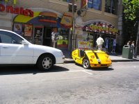
 We crossed the Bay Bridge into San Francisco. We could see a large fog bank with the tips of two towers sticking out where the Golden Gate Bridge should be. The fog seemed to be centred around the bridge. Temperatures were in the 70's, which Don assures us are much warmer than usual. This little yellow creation was one of the first we saw. They are rentals, the riders need to wear helmets and they are everywhere. Traffic, both vehicle and pedestrian, was very heavy as we moved along The Embarcadero towards Fisherman's Wharf.
 Don dropped us off at the Wharf where the cable cars start their route. He said he would meet us at the other end but I took my cell phone just in case. I didn't want to be stranded in San Francisco because I misunderstood the directions. After buying tickets, we waited for a while in line. We met a couple from Lincolnshire England on a two week visit and a family of five who
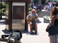
  moved to Connecticut eight years ago and were visiting their old home. We were entertained in line buy a very good singer who had an eclectic selection of songs.
As we climbed aboard the cable car, everyone jockeyed for position. We ended up in the open front seats facing right. Others were inside and some were hanging off the running boards in front of us. As the car started up the Hyde Street Hill, composed of three uphills separated by flat cross streets, it brought to mind the initial climb of a roller coaster. The hill was that steep. The operator controlled the car with two levers, one which grabbed a moving underground cable for propulsion and the other one for braking. There are sensors in the road to trip the traffic lights so that the car doesn't have to stop. We passed famous places like California Street, Lombard Street and Chinatown going up and down hills before finally arriving at the end point. There we found Don relaxing in one of the empty cable cars.
After getting to the car, we started following the 49 Mile Scenic Drive route using a tourist guide map and signs (not always there) on the side of the road. As we approached AT&T Park, it was evident that a ball game was going on. Don switched on the radio and found the game as we were in front of the park, just in time to hear someone hit a home run. We heard the cheering on the radio and then turned it off so we could hear the same cheering first hand from the stadium.
 We followed the Scenic Drive through the city with Don pointing out points of interest. Eventually, we wound our way up the end of Lombard Drive to the Coit Tower on Telegraph Hill. There was a line-up for parking so Don let us out to go inside while he waited. We bought tickets and then waited in line for about 20 minutes for
  the elevator ride to the top. The young couple ahead of us were Scandinavian and were talking back and forth (we didn't understand a
  word) with a lot of touching and kissing. I tried to study the murals on the walls around us since I didn't want to stare.
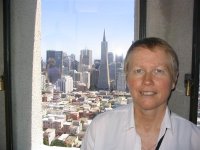
Eventually, we got to ride to the top. The view was spectacular. Alcatraz, Fisherman's Wharf, some of the Golden Gate Bridge Sandy is pictured with the Trans-America Tower, a famous SF landmark, in the background. I also got a shot of Don enjoying a Snapple as he waited for us down below. The last shot is of Sandy and Don in front of the tower.
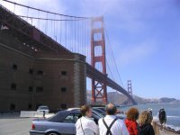
 From there, we worked our way around the shore to Fort Point, almost directly under the Golden Gate Bridge. Don and Sandy pondered the bridge as the waves crashed into the rocks in front of us. The currents under the bridge are severe, but there were a group of people obviously racing kayaks.
The next area we went through was the Presidio. We took a side trip from the official tour to check out the Officer's Club, which is now the Visitor Centre maintained by the National Park Service. We continued to and are known as Sea Cliff, which features opulent homes overlooking the Golden Gate Bridge. The lowliest of these apparently commands multi-millions of dollars. The neighborhood is immaculate and breathtaking. Strangely enough, immediately after this is a municipal golf course, Lincoln Park, owned by the City. The contrast of the rich and famous living next to the average man playing golf is kind of strange.
 We took another sidetrip to 31st Street to look at a house owned by Don's aunt and uncle. This little place, pictured here and typical of many in the area, is estimated on a real estate website to be worth from 0.9 to 1.2 million dollars. Any thought I might ever have had of relocating to San Francisco just went out the window.
We got back on track and went out by Cliff House but it was, as with many things this day, too crowded to get a parking space. We continued south down the coast along the Great Highway, getting glimpses through the dunes of the beach and surfers riding the incoming breakers. Then we looped around Lake Merced and its five golf courses, heading back north past Don's Alma Mater, San Franciso State University.
We again broke away from the route to stop for food at the Park Chow restaurant on 9th Avenue between Lincoln and Irving. Don had an eggplant concoction while Sandy and I had meatball and provolone sandwiches. The food was good. A short walk after dinner revealed Japanese, Chinese, Korean and Italian restauarants within a block. We found this area of Irving was an old style neighborhood that was formerly Jewish but was rapidly becoming an Asian enclave.
Back to the route, we took a circuitous route through Golden Gate Park and then a drive through Haight Ashbury, home of the summer of love hippy movement in the 60's. We passed right through the intersection of Haight and Ashbury Streets. Many hippies appear to still be here.
 The next stop was the top of Twin Peaks which, at 900 feet elevation, provides a panoramic view of the San Francisco area. The fog had already moved back in over the Golden Gate and we were able to watch it actually swallowing buildings in front of our eyes. It brought to mind Stephen King novels. We watched it roll in for a while, inexorably engulfing the city.
 The downtown part of the city was, as yet, untouched by the fog and spread below us (looking straight down Market Street) like a collection of toy houses.
Twin Peaks brought and end to the tour and we worked our way back across the Mission District to Highway 101 South and on to the San Mateo Bridge. Don commented on how light the traffic was as we returned to Stockton via interstates.
Back at the house, Sandy turned on the Weather Channel to watch a special called "It Could Happen Tomorrow". This dealt with the possibility of another San Francisco earthquake with a magnitude of the one that occurred 100 years ago. Many of the shots in the program were of places we were at today. Then Sandy turned in, I worked on the Blog and Don plotted the route for tomorrow's visit to Monterey.


No comments:
Post a Comment